February 11, 2026
Open Geoscience + Repeatable Monitoring: The New Standard for Closure and Compliance
As mine closure and rehabilitation timelines extend, the challenge is no longer finding data, it’s proving change, consistently, over time.
Australia has one of the most comprehensive open geoscience ecosystems in the world. Federal and state platforms expose elevation, geology, geophysics, tenure, and extensive open‑file records, most of it delivered through modern web services that plug straight into enterprise data platforms such as your GIS.
For mining and infrastructure organisations, this means the foundations for defensible, regulator‑ready evidence already exist. The differentiator is no longer access, it is how consistently these datasets are captured, ingested, aligned, analysed, refreshed, and explained over time. It is the discipline of the data workflow, not just the specs of the data capture.
Executive Takeaway
Compliance is now an evidence discipline, not a document exercise.
Australia’s National Mine Closure Guidelines: Mine closure | Leading practice handbooks for sustainable mining | Department of Industry Science and Resources
Across WA, QLD, and NSW, regulators expect consistent, spatially explicit, and repeatable datasets that explain not just what the land looks like today—but how and why it changed over time, and how reliable your evidence of this change is.
Australia’s public geoscience platforms already provide the building blocks. The advantage comes from building on this to create an operational system for monitoring and reporting in closure, rehabilitation, and regulatory confidence
If you are preparing for your next closure milestone or annual reporting cycle, Outline Global can help you design defensible, auditable evidence frameworks and a monitoring cadence tied to reporting milestones that your GIS, reporting, environmental compliance teams can run with year after year.
For GIS, environment, and closure teams, the challenge should be less about finding datasets and more about producing evidence you can defend under audit, across multiple years, with minimal rework.

Mining is complex enough. Your data shouldn’t be.
With that in mind, below we hope to shortcut the dataset discovery process by outlining the key public datasets that can serve as the baseline to build on for mine closure, rehabilitation, and regulatory reporting, organised by discipline and state, with a focus on WA, QLD, and NSW.
Core Dataset Disciplines (What GIS Teams Need)
- Elevation, Landform & Topography
Purpose: Landform stability, drainage, erosion, “safe and stable” closure criteria
Typical layers: DEM, DSM, LiDAR‑derived surfaces, elevation grids
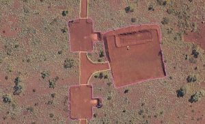
- Disturbance & Land‑Use Change
Purpose: Annual disturbance reporting, progressive rehabilitation tracking
Typical layers: Disturbance footprints, tenure boundaries, planned vs actual, time‑series change
- Geophysics (Stability & Risk Context)
Purpose: Structural controls, seepage pathways, erosion susceptibility
Typical layers: Magnetics, radiometrics, gravity, electromagnetic surveys
- Geochemistry (Baseline & Contamination Context)
Purpose: Background conditions, closure risk, post‑mining land‑use suitability
Typical layers: Soil and stream geochemistry, regional geochemical surveys
- Vegetation & Surface Cover Context
Purpose: Rehabilitation trajectory, land capability, canopy structure
Typical layers: Regolith proxies, radiometrics, land system mapping
- Historic & Open‑File Records
Purpose: Legacy disturbance, audit defensibility, historical explanation
Typical layers: Open‑file exploration reports, drilling, historic surveys
Individually these datasets are familiar. The challenge is making them comparable, repeatable, and defensible as a single evidence system.
Where public data stops and compliance evidence starts
- This public data provides baselines, regional context, and defensible references
- Compliance decisions require site specific evidence, consistent method, and documented lineage over time and across the land
- The key to this is rigorous operational evidence capture, supported by consistent methods, QA, and audit ready packaging
Dataset Landscape by State
Western Australia (WA)
Computer-vision AI assisted modelling
WA’s high‑resolution statewide geophysical compilations provide exceptional regional closure context and support long‑term monitoring frameworks.
Best‑known for: Depth, resolution, and regional consistency
Key datasets & portals
- GeoVIEW.WA – geology, titles, mines, elevation, geophysics, WAMEX
👉 https://www.wa.gov.au/service/natural-resources/mineral-resources/geoview-search-geoscience-and-titles-information - GSWA Statewide Geophysical Compilation Grids (magnetics, radiometrics)
👉 https://pawsey.org.au/projects/gswa-state-geophysical-compilation-grids/
Queensland (QLD)
Queensland’s open data infrastructure is API‑friendly, making it ideal for repeatable rehabilitation and dam‑safety reporting workflows.
Best‑known for: Scale, API access, and reporting integration
Key datasets & portals
- GSQ Open Data Portal – elevation, geophysics, geochemistry, reports
👉 https://geoscience.data.qld.gov.au/ - GeoResGlobe – interactive geoscience and tenure mapping
👉 https://georesglobe.information.qld.gov.au/
New South Wales (NSW)
NSW aligns strongly with auditable, spatially explicit rehabilitation evidence, reflecting increasing regulatory scrutiny.
Best‑known for: Transparency and audit‑ready accessibility
Key datasets & portals
- MinView – geology, mines, titles, geophysics, geochemistry, historic data
👉 https://minview.geoscience.nsw.gov.au/
National Datasets (All States)
- Geoscience Australia – Data & Publications
👉 https://www.ga.gov.au/data-pubs - Geoscientific Datasets & Reports
👉 https://www.ga.gov.au/data-pubs/Geoscientific-Datasets-and-Reports - GeoInsight WMTS (national aggregated services)
👉 https://data.gov.au/data/dataset/b2d756f3-9b17-4847-bc16-21beb38dbde5 - GADDS – Geophysical Archive Data Delivery System
👉 Geophysical Archive Data Delivery System
Building on Public Data for Regulator‑Ready Evidence

DEM and Contour Measurements
To move from datasets to defensible compliance:
- Start national, then localise using federal baselines and state detail
- Standardise disturbance time‑series (approved / active / rehab / legacy)
- Establish a monitoring cadence for predictable, consistent and reliable data gathering on site
- Maintain consistent methods and lineage so change detection is comparable over time
- Use geochemistry and historic records to explain risk and legacy impacts
- Treat metadata as evidence: capture source, date, resolution, and method